Faidhle:North Coast of Hoy - geograph.org.uk - 1369432.jpg
Chan eil dùmhlachd-bhreacaidh nas fhearr ri fhaighinn.
North_Coast_of_Hoy_-_geograph.org.uk_-_1369432.jpg (640 × 480 pixel, meud an fhaidhle: 43 KB, seòrsa MIME: image/jpeg)
Gearr-chunntas
| Tuairisgeul |
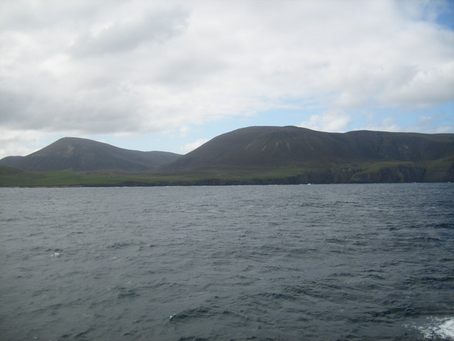
English: North Coast of Hoy Showing the grassy slopes between Murra and Hoy Sound to the left of the picture. Ward Hill (479m), the highest mountain in Orkney, lies immediately behind with Cuilags/Lounders Fea to the right. The cliffs of St John's Head are just off the right of the picture. |
| Ceann-là | |
| Tùs | From geograph.org.uk |
| Ùghdar | Ivan Hall |
| Urram (required by the license) | Ivan Hall / North Coast of Hoy / |
| Object location | | View this and other nearby images on: OpenStreetMap |
|---|
_heading:157.00&language=gd)
Ceadachadh

|
This image was taken from the Geograph project collection. See this photograph's page on the Geograph website for the photographer's contact details. The copyright on this image is owned by Ivan Hall and is licensed for reuse under the Creative Commons Attribution-ShareAlike 2.0 license.
|
This file is licensed under the Creative Commons Attribution-Share Alike 2.0 Generic license.
Urram: Ivan Hall
- Faodaidh tu:
- a cho-roinneadh – lethbhreac a dhèanamh dhen obair, a sgaoileadh is a tar-chur
- ath-mheasgachadh – an obair atharrachadh
- Fo bhuaidh nan cumhaichean a leanas:
- urram – Feumaidh tu iomradh a thoirt air an ùghdar no an neach aig a bheil cead air, dìreach mar a thoill iad (ach chan ann air dòigh a chuireas an sùilean dhaoine gu bheil iad ag aontachadh riut no ri d’ obair).
- co-roinneadh co-ionnann – Ma dh’atharraicheas tu no ma leasaicheas tu an obair seo, ’s urrainn an tionndadh ùr fon cheadachas seo no fo cheadachas coltach ris.
Eachdraidh an fhaidhle
Briog air ceann-là/àm gus am faidhle a shealltainn mar a nochd e aig an àm sin.
| Ceann-là/Àm | Dealbhag | Meud | Cleachdaiche | Beachd | |
|---|---|---|---|---|---|
| làithreach | 11:51, 28 dhen Ghearran 2011 | | 640 × 480 (43 KB) | GeographBot | == {{int:filedesc}} == {{Information |description={{en|1=North Coast of Hoy Showing the grassy slopes between Murra and Hoy Sound to the left of the picture. Ward Hill (479m), the highest mountain in Orkney, lies immediately behind with Cuilags/Lounders F |
Cleachdadh an fhaidhle
Tha ceangal ris an fhaidhle seo san duilleag a leanas: