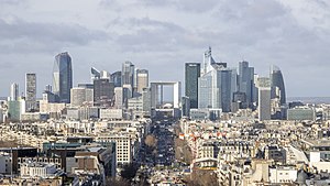
Hauts-de-Seine
'S e département na Frainge a tha ann an Hauts-de-Seine. Tha e na laighe ann an Île-de-France. 'S e Nanterre am prìomh-bhaile.
Hauts-de-Seine
| Cur air cois | 1 dhen Fhaoilleach 1968 |
|---|---|
| Ainm oifigeil | Hauts-de-Seine |
| Ainmichte às dèidh | Seine |
| Dùthaich | An Fhraing |
| Prìomh-bhaile | Nanterre |
| Sgìre riaghaltais ionadail | Île-de-France |
| Roinn-tìde | UTC+01:00, UTC+02:00 |
| Domhan-leud is -fhad | 48°50′0″N 2°12′0″E |
| Coordinates of easternmost point | 48°56′4″N 2°20′13″E |
| Coordinates of northernmost point | 48°57′4″N 2°17′27″E |
| Coordinates of southernmost point | 48°43′45″N 2°18′29″E |
| Coordinates of westernmost point | 48°50′22″N 2°8′44″E |
| Puing as àirde | Q26897900 |
| Oifis aig ceann an riaghaltais | president of departmental council |
| Ceannard an riaghaltais | Patrick Devedjian |
| Baile-céile | Nanjing |
| A’ gabhail a-steach | Yves du Manoir Stadium |
| Na bh’ann roimhe | Seine, Yvelines |
| Làrach-lìn | https://www.hauts-de-seine.gouv.fr, https://www.hauts-de-seine.fr |
| Bratach | flag of Hauts-de-Seine |
| Geography of topic | geography of Hauts-de-Seine |
| List of monuments | Q3252373 |
| Open data portal | opendata.hauts-de-seine.fr |
| Economy of topic | economy of Hauts-de-Seine |
| Demographics of topic | demographics of Hauts-de-Seine |
| Category for maps or plans | Category:Maps of Hauts-de-Seine |


