Viking_expansion.png(507 × 310 pixel, meud an fhaidhle: 109 KB, seòrsa MIME: image/png)

'S ann à Wikimedia Commons a tha am faidhle seo agus faodaidh gu bheil pròiseactan eile 'ga chleachdadh. Chì thu an tuairisgeul a tha aice air [duilleag tuairisgeul an fhaidhle https://commons.wikimedia.org/wiki/File:Viking_expansion.png] gu h-ìosal.

(see en:File talk:Viking Expansion.svg)

Gearr-chunntas

Tuairisgeul
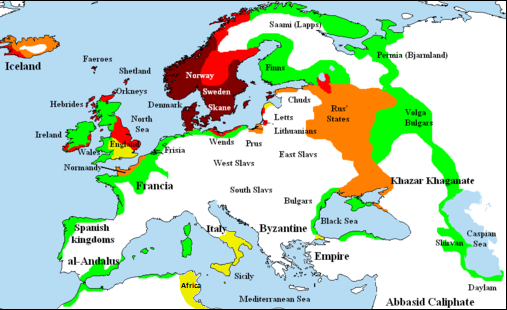
English: Map showing area of Scandinavian settlement (Vikings and Normans descendants from Normandy) in
 
eighth century
 
ninth century
 
tenth century
 
eleventh century
 
denotes areas subjected to frequent Scandinavian contacts, but with little or no Scandinavian settlement
Ceann-là 14 dhen t-Samhain 2006 (original upload date)
Tùs Briangotts (original uploader)
Ùghdar Briangotts (original uploader)
Cead
(Ag ath-chleachdadh an fhaidhle seo)
I, the copyright holder of this work, hereby publish it under the following licenses:
GNU head Permission is granted to copy, distribute and/or modify this document under the terms of the GNU Free Documentation License, Version 1.2 or any later version published by the Free Software Foundation; with no Invariant Sections, no Front-Cover Texts, and no Back-Cover Texts. A copy of the license is included in the section entitled GNU Free Documentation License.
w:en:Creative Commons
urram co-roinneadh co-ionnann
Tha am faidhle seo fo cheadachas Creative Commons Attribution-Share Alike 3.0 Unported.
Faodaidh tu:
  • a cho-roinneadh – lethbhreac a dhèanamh dhen obair, a sgaoileadh is a tar-chur
  • ath-mheasgachadh – an obair atharrachadh
Fo bhuaidh nan cumhaichean a leanas:
  • urram – Feumaidh tu iomradh a thoirt air an ùghdar no an neach aig a bheil cead air, dìreach mar a thoill iad (ach chan ann air dòigh a chuireas an sùilean dhaoine gu bheil iad ag aontachadh riut no ri d’ obair).
  • co-roinneadh co-ionnann – Ma dh’atharraicheas tu no ma leasaicheas tu an obair seo, ’s urrainn an tionndadh ùr fon cheadachas seo no fo cheadachas coltach ris.
This licensing tag was added to this file as part of the GFDL licensing update.
’S urrainn dhut an ceadachas as fhearr leat a thaghadh.
Other versions

[deasaich]

File:Viking Expansion.svg is a vector version of this file. It should be used in place of this PNG file when not inferior.

File:Viking expansion.png → File:Viking Expansion.svg

For more information, see Help:SVG.

In other languages
Alemannisch  Bahasa Indonesia  Bahasa Melayu  British English  català  čeština  dansk  Deutsch  eesti  English  español  Esperanto  euskara  français  Frysk  galego  hrvatski  Ido  italiano  lietuvių  magyar  Nederlands  norsk bokmål  norsk nynorsk  occitan  Plattdüütsch  polski  português  português do Brasil  română  Scots  sicilianu  slovenčina  slovenščina  suomi  svenska  Tiếng Việt  Türkçe  vèneto  Ελληνικά  беларуская (тарашкевіца)  български  македонски  нохчийн  русский  српски / srpski  татарча/tatarça  українська  ქართული  հայերեն  বাংলা  தமிழ்  മലയാളം  ไทย  한국어  日本語  简体中文  繁體中文  עברית  العربية  فارسی  +/−
New SVG image

Captions

Add a one-line explanation of what this file represents

Items portrayed in this file

depicts Beurla

14 dhen t-Samhain 2006

media type Beurla

image/png

Eachdraidh an fhaidhle

Briog air ceann-là/àm gus am faidhle a shealltainn mar a nochd e aig an àm sin.

(as ùire | as sine) Seall (na 10 nas ùire | ) (10 | 20 | 50 | 100 | 250 | 500).
Ceann-là/ÀmDealbhagMeudCleachdaicheBeachd
làithreach22:58, 25 dhen Ghearran 2018Dealbhag airson an tionndaidh on 22:58, 25 dhen Ghearran 2018507 × 310 (109 KB)AsmodimAdded the territory of the Norman "Kingdom of Africa (see the wikipedia article), conquests of the Norman kingdom of Sicily under Roger II
18:10, 5 dhen Lùnastal 2016Dealbhag airson an tionndaidh on 18:10, 5 dhen Lùnastal 2016507 × 310 (109 KB)TheutatisExpanded area in Italy according to Norman expansion.
10:52, 17 dhen Iuchar 2008Dealbhag airson an tionndaidh on 10:52, 17 dhen Iuchar 2008800 × 310 (140 KB)F7~commonswiki
21:14, 15 dhen Chèitean 2007Dealbhag airson an tionndaidh on 21:14, 15 dhen Chèitean 20071,464 × 568 (51 KB)Briangotts== Summary == {{Information |Description= Map showing area of Scandinavian settlement in<br> {{legend|#800000|eighth centuries}} {{legend|#f00|ninth centuries}} {{legend|#ff8000|tenth centuries}} {{legend|#eded00|eleventh centuries}} {{legend|#0f0|denotes
13:58, 10 dhen Chèitean 2007Dealbhag airson an tionndaidh on 13:58, 10 dhen Chèitean 20071,464 × 568 (51 KB)Briangotts== Summary == {{Information |Description= Map showing area of Scandinavian settlement in<br> {{legend|#800000|eighth century}} {{legend|#f00|ninth century}} {{legend|#ff8000|tenth century}} {{legend|#eded00|eleventh century}} {{legend|#0f0|denotes areas s
19:56, 16 dhen Ghiblean 2007Dealbhag airson an tionndaidh on 19:56, 16 dhen Ghiblean 20071,464 × 568 (33 KB)Tene~commonswikiOptimised (0)
11:43, 23 dhen Ghearran 2007Dealbhag airson an tionndaidh on 11:43, 23 dhen Ghearran 20071,464 × 568 (79 KB)Dbachmann"yellow"
11:33, 23 dhen Ghearran 2007Dealbhag airson an tionndaidh on 11:33, 23 dhen Ghearran 20071,464 × 568 (80 KB)Dbachmanncropped, fiddled with Iceland.
18:58, 2 dhen Ghearran 2007Dealbhag airson an tionndaidh on 18:58, 2 dhen Ghearran 20071,838 × 710 (62 KB)Tene~commonswikiOptimised (0)
12:50, 20 dhen Fhaoilleach 2007Dealbhag airson an tionndaidh on 12:50, 20 dhen Fhaoilleach 20071,838 × 710 (110 KB)Liftarn{{Information |Description=Map showing area of Scandinavian settlement in the eighth (dark red), ninth (red), tenth (orange) and eleventh (yellow) centuries. Green denotes areas subjected to frequent en:Viking raids. [[:e
(as ùire | as sine) Seall (na 10 nas ùire | ) (10 | 20 | 50 | 100 | 250 | 500).

Chan eil duilleag sam bith a' ceangal an-seo.

Cleachdadh fhaidhlichean uile-choitcheann

Tha na uicidhean eile a leanas a’ cleachdadh an fhaidhle seo

Metadata