Faidhle:Uruguay mapa.png
Chan eil dùmhlachd-bhreacaidh nas fhearr ri fhaighinn.
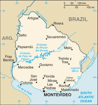
Uruguay_mapa.png (329 × 353 pixel, meud an fhaidhle: 32 KB, seòrsa MIME: image/png)
Mapa de Uruguay.
Fuente: CIA The World Factbook 2004 archive copy at the Wayback Machine
This image is in the public domain because it contains materials that originally came from the United States Central Intelligence Agency's World Factbook.
|
 |
Eachdraidh an fhaidhle
Briog air ceann-là/àm gus am faidhle a shealltainn mar a nochd e aig an àm sin.
| Ceann-là/Àm | Dealbhag | Meud | Cleachdaiche | Beachd | |
|---|---|---|---|---|---|
| làithreach | 04:35, 14 dhen t-Sultain 2012 | | 329 × 353 (32 KB) | Thricecube | Updated version |
| 12:12, 23 dhen Dùbhlachd 2004 |  | 330 × 354 (12 KB) | Tano4595 | Mapa de Uruguay |
Cleachdadh an fhaidhle
Tha ceangal ris an fhaidhle seo san duilleag a leanas:
Cleachdadh fhaidhlichean uile-choitcheann
Tha na uicidhean eile a leanas a’ cleachdadh an fhaidhle seo
- Cleachdadh air af.wikipedia.org
- Cleachdadh air ast.wikipedia.org
- Cleachdadh air azb.wikipedia.org
- Cleachdadh air az.wikipedia.org
- Cleachdadh air be-tarask.wikipedia.org
- Cleachdadh air bg.wikipedia.org
- Cleachdadh air bn.wikipedia.org
- Cleachdadh air br.wikipedia.org
- Cleachdadh air ca.wikipedia.org
- Cleachdadh air cs.wikipedia.org
- Cleachdadh air da.wikipedia.org
- Cleachdadh air de.wikipedia.org
- Cleachdadh air de.wikibooks.org
- Cleachdadh air dsb.wikipedia.org
- Cleachdadh air el.wikipedia.org
- Cleachdadh air en.wikipedia.org
- Cleachdadh air en.wikibooks.org
- Cleachdadh air eo.wikipedia.org
- Cleachdadh air es.wikipedia.org
- Cleachdadh air fa.wikipedia.org
Seall an corr dhen chleachdadh uile-choitcheann a nithear dhen fhaidhle seo.