Faidhle:US Secession map 1861.svg

Size of this PNG preview of this SVG file: 787 × 483 piogsail. Dùmhlachdan-breacaidh eile: 320 × 196 piogsail | 640 × 393 piogsail | 1,024 × 628 piogsail | 1,280 × 786 piogsail | 2,560 × 1,571 piogsail.
Am faidhle tùsail (Faidhle SVG, a-rèir ainm 787 × 483 pixel, meud faidhle: 111 KB)
Gearr-chunntas
{{Information
|Description=
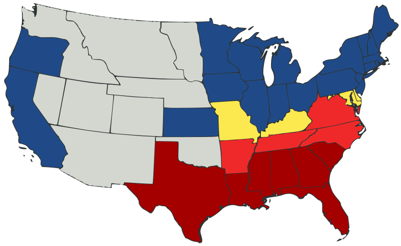
English: United States map of 1861, showing affiliation of states and territories regarding secession from the Union at the start of the American Civil War.
Legend:
States that seceded before April 15, 1861
States that seceded after April 15, 1861
States that permitted slavery, but did not secede
States of the Union where slavery was banned
U.S. territories, under Union Army control
|Date=2007-02-23
|Source=
A trace, retouch, and recolour of Image:Secession Map of the United States, 1861.png by User:Tomf688.
|Author=[[User:ions= |Other fields= }}
Ceadachadh
Tha am faidhle seo fo cheadachas Creative Commons Attribution-Share Alike 3.0 Unported.
- Faodaidh tu:
- a cho-roinneadh – lethbhreac a dhèanamh dhen obair, a sgaoileadh is a tar-chur
- ath-mheasgachadh – an obair atharrachadh
- Fo bhuaidh nan cumhaichean a leanas:
- urram – Feumaidh tu iomradh a thoirt air an ùghdar no an neach aig a bheil cead air, dìreach mar a thoill iad (ach chan ann air dòigh a chuireas an sùilean dhaoine gu bheil iad ag aontachadh riut no ri d’ obair).
- co-roinneadh co-ionnann – Ma dh’atharraicheas tu no ma leasaicheas tu an obair seo, ’s urrainn an tionndadh ùr fon cheadachas seo no fo cheadachas coltach ris.
Eachdraidh an fhaidhle
Briog air ceann-là/àm gus am faidhle a shealltainn mar a nochd e aig an àm sin.
| Ceann-là/Àm | Dealbhag | Meud | Cleachdaiche | Beachd | |
|---|---|---|---|---|---|
| làithreach | 23:47, 23 dhen Ghearran 2007 | | 787 × 483 (111 KB) | Tintazul | {{Tintazul |Description=United States map of 1861, show affiliation of states and territories regarding the Secession War (Civil War.) Legend: {{legend|#A40000|States that seceded before April 15, 1861}} {{legend|#EF2929|States that seceded after April 15 |
Cleachdadh an fhaidhle
Tha ceangal ris an fhaidhle seo san duilleag a leanas:
Cleachdadh fhaidhlichean uile-choitcheann
Tha na uicidhean eile a leanas a’ cleachdadh an fhaidhle seo
- Cleachdadh air ar.wikipedia.org
- Cleachdadh air arz.wikipedia.org
- Cleachdadh air be.wikipedia.org
- Cleachdadh air bg.wikipedia.org
- Cleachdadh air bs.wikipedia.org
- Cleachdadh air cy.wikipedia.org
- Cleachdadh air da.wikipedia.org
- Cleachdadh air el.wikipedia.org
- Cleachdadh air en.wikipedia.org
- American Civil War
- Irredentism
- Origins of the American Civil War
- User:Jimmuldrow/Sandbox
- Upland South
- User:ArmyAnt/Sandbox
- Presidency of Abraham Lincoln
- Presidency of James Buchanan
- James Buchanan
- Central Confederacy
- User:Themaster1112/sandbox
- User:2know4power/sandbox
- User:LukeRun82
- User:Orser67/Lincoln
- Cleachdadh air es.wikipedia.org
- Cleachdadh air eu.wikipedia.org
- Cleachdadh air he.wikipedia.org
- Cleachdadh air hr.wikipedia.org
- Cleachdadh air hy.wikipedia.org
- Cleachdadh air it.wikipedia.org
- Cleachdadh air ka.wikipedia.org
- Cleachdadh air lij.wikipedia.org
- Cleachdadh air lt.wikipedia.org
- Cleachdadh air ml.wikipedia.org
- Cleachdadh air ne.wikipedia.org
- Cleachdadh air no.wikipedia.org
- Cleachdadh air pl.wikipedia.org
- Cleachdadh air pt.wikipedia.org
- Cleachdadh air ro.wikipedia.org
Seall an corr dhen chleachdadh uile-choitcheann a nithear dhen fhaidhle seo.