Faidhle:Slateford Aqueduct and Viaduct - geograph.org.uk - 1532265.jpg
Chan eil dùmhlachd-bhreacaidh nas fhearr ri fhaighinn.
Slateford_Aqueduct_and_Viaduct_-_geograph.org.uk_-_1532265.jpg (640 × 480 pixel, meud an fhaidhle: 79 KB, seòrsa MIME: image/jpeg)
Gearr-chunntas
| Tuairisgeul |
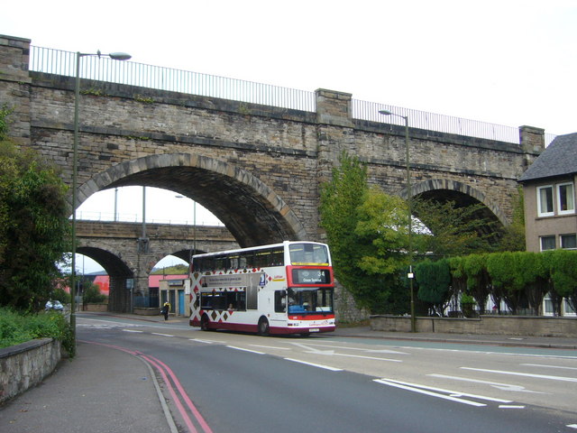
English: Slateford Aqueduct and Viaduct, Edinburgh, Great Britain. The aqueduct in the foreground was built in 1822 to carry the Union Canal across Inglis Green Road and the Water of Leith, its eight arches running for a total length of 600 feet. Thomas Telford described it as "superior perhaps to any aqueduct in the kingdom". The railway viaduct behind it was built in 1847 by William Arrol who went on to build the Bothwell, Broomielaw, second Tay and Forth bridges and London's Tower Bridge. |
| Ceann-là | |
| Tùs | From geograph.org.uk; transferred by User:Ultra7 using geograph_org2commons. |
| Ùghdar | kim traynor |
| Cead (Ag ath-chleachdadh an fhaidhle seo) |
Creative Commons Attribution Share-alike license 2.0 |
| Other versions | |
| Urram (required by the license) | kim traynor / Slateford Aqueduct and Viaduct / |

| Camera location | | View this and other nearby images on: OpenStreetMap |
|---|
| Object location | | View this and other nearby images on: OpenStreetMap |
|---|
_region:GB-GBN_heading:337.00&language=gd)
Ceadachadh

|
This image was taken from the Geograph project collection. See this photograph's page on the Geograph website for the photographer's contact details. The copyright on this image is owned by kim traynor and is licensed for reuse under the Creative Commons Attribution-ShareAlike 2.0 license.
|
This file is licensed under the Creative Commons Attribution-Share Alike 2.0 Generic license.
Urram: kim traynor
- Faodaidh tu:
- a cho-roinneadh – lethbhreac a dhèanamh dhen obair, a sgaoileadh is a tar-chur
- ath-mheasgachadh – an obair atharrachadh
- Fo bhuaidh nan cumhaichean a leanas:
- urram – Feumaidh tu iomradh a thoirt air an ùghdar no an neach aig a bheil cead air, dìreach mar a thoill iad (ach chan ann air dòigh a chuireas an sùilean dhaoine gu bheil iad ag aontachadh riut no ri d’ obair).
- co-roinneadh co-ionnann – Ma dh’atharraicheas tu no ma leasaicheas tu an obair seo, ’s urrainn an tionndadh ùr fon cheadachas seo no fo cheadachas coltach ris.
Eachdraidh an fhaidhle
Briog air ceann-là/àm gus am faidhle a shealltainn mar a nochd e aig an àm sin.
| Ceann-là/Àm | Dealbhag | Meud | Cleachdaiche | Beachd | |
|---|---|---|---|---|---|
| làithreach | 16:40, 15 dhen t-Sultain 2010 | | 640 × 480 (79 KB) | File Upload Bot (Magnus Manske) | == {{int:filedesc}} == {{Information |Description={{en|1=Slateford Aqueduct and Viaduct, near to Craiglockhart, Edinburgh, Great Britain. The aqueduct in the foreground was built in 1822 to carry the Union Canal across Inglis Green Road and the Water of L |
Cleachdadh an fhaidhle
Tha ceangal ris an fhaidhle seo san duilleag a leanas:
Cleachdadh fhaidhlichean uile-choitcheann
Tha na uicidhean eile a leanas a’ cleachdadh an fhaidhle seo
- Cleachdadh air en.wikipedia.org
- Cleachdadh air www.wikidata.org