Faidhle:Round Tower - Clondalkin - geograph.org.uk - 108911.jpg
Meud an ro-sheallaidh seo: 449 × 600 piogsail. Dùmhlachdan-breacaidh eile: 179 × 240 piogsail | 479 × 640 piogsail.
Am faidhle tùsail (479 × 640 pixel, meud an fhaidhle: 66 KB, seòrsa MIME: image/jpeg)
Gearr-chunntas
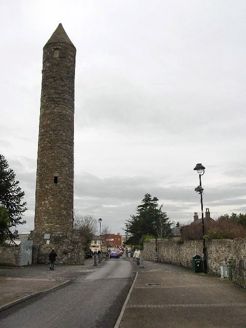
| Tuairisgeul |
English: Round Tower - Clondalkin. Well preserved 8th century round tower that acts as a focal point for the area. Acknowledged as one of the oldest and best preserved in the country, it is 84 feet high and has its original conical cap. The foundation of the first monastery is attributed to St. Cronan, otherwise called Mo-Chua, who lived possibly in the 6th century. The monastery is first mentioned in 776. It was plundered by the Vikings in 832. [info from http://www.irish-architecture.com] |
| Ceann-là | |
| Tùs | From geograph.org.uk |
| Ùghdar | Paul Johnston-Knight |
| Urram (required by the license) | Paul Johnston-Knight / Round Tower - Clondalkin / |
| Object location | | View this and other nearby images on: OpenStreetMap |
|---|
_heading:0.00&language=gd)
Ceadachadh

|
This image was taken from the Geograph project collection. See this photograph's page on the Geograph website for the photographer's contact details. The copyright on this image is owned by Paul Johnston-Knight and is licensed for reuse under the Creative Commons Attribution-ShareAlike 2.0 license.
|
This file is licensed under the Creative Commons Attribution-Share Alike 2.0 Generic license.
Urram: Paul Johnston-Knight
- Faodaidh tu:
- a cho-roinneadh – lethbhreac a dhèanamh dhen obair, a sgaoileadh is a tar-chur
- ath-mheasgachadh – an obair atharrachadh
- Fo bhuaidh nan cumhaichean a leanas:
- urram – Feumaidh tu iomradh a thoirt air an ùghdar no an neach aig a bheil cead air, dìreach mar a thoill iad (ach chan ann air dòigh a chuireas an sùilean dhaoine gu bheil iad ag aontachadh riut no ri d’ obair).
- co-roinneadh co-ionnann – Ma dh’atharraicheas tu no ma leasaicheas tu an obair seo, ’s urrainn an tionndadh ùr fon cheadachas seo no fo cheadachas coltach ris.
Eachdraidh an fhaidhle
Briog air ceann-là/àm gus am faidhle a shealltainn mar a nochd e aig an àm sin.
| Ceann-là/Àm | Dealbhag | Meud | Cleachdaiche | Beachd | |
|---|---|---|---|---|---|
| làithreach | 09:31, 8 dhen Ghiblean 2011 | | 479 × 640 (66 KB) | Hydro | Tonwertkorrektur |
| 01:33, 31 dhen Fhaoilleach 2010 |  | 479 × 640 (60 KB) | GeographBot | == {{int:filedesc}} == {{Information |description={{en|1=Round Tower - Clondalkin. Well preserved 8th century round tower that acts as a focal point for the area. Acknowledged as one of the oldest and best preserved in the country, it is 84 feet high and |
Cleachdadh an fhaidhle
Tha ceangal ris an fhaidhle seo san duilleag a leanas:
Cleachdadh fhaidhlichean uile-choitcheann
Tha na uicidhean eile a leanas a’ cleachdadh an fhaidhle seo
- Cleachdadh air be-tarask.wikipedia.org
- Cleachdadh air bg.wikipedia.org
- Cleachdadh air ca.wikipedia.org
- Cleachdadh air ceb.wikipedia.org
- Cleachdadh air de.wikipedia.org
- Cleachdadh air en.wikipedia.org
- Cleachdadh air es.wikipedia.org
- Cleachdadh air eu.wikipedia.org
- Cleachdadh air fa.wikipedia.org
- Cleachdadh air fr.wikipedia.org
- Cleachdadh air ga.wikipedia.org
- Cleachdadh air he.wikipedia.org
- Cleachdadh air it.wikipedia.org
- Cleachdadh air ka.wikipedia.org
- Cleachdadh air nl.wikipedia.org
- Cleachdadh air pl.wikipedia.org
- Cleachdadh air ru.wikipedia.org
- Cleachdadh air sl.wikipedia.org
- Cleachdadh air sv.wikipedia.org
- Cleachdadh air ur.wikipedia.org
- Cleachdadh air www.wikidata.org