Faidhle:River Nith estuary.jpg

Meud an ro-sheallaidh seo: 800 × 533 piogsail. Dùmhlachdan-breacaidh eile: 320 × 213 piogsail | 640 × 427 piogsail | 1,024 × 683 piogsail | 1,280 × 853 piogsail | 2,560 × 1,707 piogsail | 3,504 × 2,336 piogsail.
Am faidhle tùsail (3,504 × 2,336 pixel, meud an fhaidhle: 8.68 MB, seòrsa MIME: image/jpeg)
Gearr-chunntas
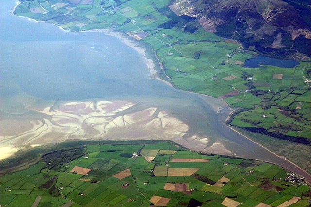
| Tuairisgeul | The estuary of the River Nith, Scotland, at low tide; opening into Solway Firth. This is a view of the Nith estuary from the north-east. The group of buildings at bottom right is the village of Glencaple. At bottom left near the wooded area is Caerlaverock Castle. At top right is Loch Kindar and the hill above is called Criffel. Just beyond the top left of photo is the birthplace of John Paul Jones. |
| Ceann-là | |
| Tùs | https://www.flickr.com/photos/52614599@N00/483602946 |
| Ùghdar | Doc Searls from Santa Barbara, USA |
Ceadachadh
This file is licensed under the Creative Commons Attribution-Share Alike 2.0 Generic license.
- Faodaidh tu:
- a cho-roinneadh – lethbhreac a dhèanamh dhen obair, a sgaoileadh is a tar-chur
- ath-mheasgachadh – an obair atharrachadh
- Fo bhuaidh nan cumhaichean a leanas:
- urram – Feumaidh tu iomradh a thoirt air an ùghdar no an neach aig a bheil cead air, dìreach mar a thoill iad (ach chan ann air dòigh a chuireas an sùilean dhaoine gu bheil iad ag aontachadh riut no ri d’ obair).
- co-roinneadh co-ionnann – Ma dh’atharraicheas tu no ma leasaicheas tu an obair seo, ’s urrainn an tionndadh ùr fon cheadachas seo no fo cheadachas coltach ris.
| This image was originally posted to Flickr by dsearls at https://www.flickr.com/photos/52614599@N00/483602946. It was reviewed on 5 dhen Chèitean 2007 by FlickreviewR and was confirmed to be licensed under the terms of the cc-by-sa-2.0. |
This is a view of the Nith estuary from the north-east. The group of buildings at bottom right is the village of Glencaple. At bottom left near the wooded area is Caerlaverock Castle. At top right is Loch Kindar and the hill above is called Criffel. Just beyond the top left of photo is the birthplace of John Paul Jones.
Eachdraidh an fhaidhle
Briog air ceann-là/àm gus am faidhle a shealltainn mar a nochd e aig an àm sin.
| Ceann-là/Àm | Dealbhag | Meud | Cleachdaiche | Beachd | |
|---|---|---|---|---|---|
| làithreach | 07:14, 5 dhen Chèitean 2007 | | 3,504 × 2,336 (8.68 MB) | Sandstein | {{Information |Description= The estuary of the River Nith, Scotland, at low tide; opening into Solway Firth. On the near shore, Bowness-on-Solway. On the far, Annan, in Dumfries and Galloway. |Source= http://www.flickr.com/photos/52614599@N00/483602946 |D |
Cleachdadh an fhaidhle
Tha ceangal ris an fhaidhle seo san duilleag a leanas:
Cleachdadh fhaidhlichean uile-choitcheann
Tha na uicidhean eile a leanas a’ cleachdadh an fhaidhle seo
- Cleachdadh air ar.wikipedia.org
- Cleachdadh air arz.wikipedia.org
- Cleachdadh air ast.wikipedia.org
- Cleachdadh air bn.wikipedia.org
- Cleachdadh air br.wikipedia.org
- Cleachdadh air ceb.wikipedia.org
- Cleachdadh air cs.wikipedia.org
- Cleachdadh air cy.wikipedia.org
- Cleachdadh air dag.wikipedia.org
- Cleachdadh air de.wikipedia.org
- Cleachdadh air en.wikipedia.org
- Cleachdadh air en.wikivoyage.org
- Cleachdadh air eo.wikipedia.org
- Cleachdadh air es.wikipedia.org
- Cleachdadh air eu.wikipedia.org
- Cleachdadh air fa.wikipedia.org
- Cleachdadh air fr.wikipedia.org
- Cleachdadh air fy.wikipedia.org
- Cleachdadh air ga.wikipedia.org
- Cleachdadh air gv.wikipedia.org
- Cleachdadh air hak.wikipedia.org
- Cleachdadh air id.wikipedia.org
- Cleachdadh air incubator.wikimedia.org
- Cleachdadh air it.wikipedia.org
- Cleachdadh air it.wikibooks.org
- Cleachdadh air it.wikiversity.org
- Cleachdadh air ja.wikipedia.org
- Cleachdadh air kbd.wikipedia.org
- Cleachdadh air lt.wikipedia.org
- Cleachdadh air nl.wikipedia.org
Seall an corr dhen chleachdadh uile-choitcheann a nithear dhen fhaidhle seo.