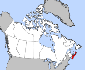
Faidhle:Nova Scotia-map.png
Nova_Scotia-map.png (280 × 230 pixel, meud an fhaidhle: 14 KB, seòrsa MIME: image/png)
Eachdraidh an fhaidhle
Briog air ceann-là/àm gus am faidhle a shealltainn mar a nochd e aig an àm sin.
| Ceann-là/Àm | Dealbhag | Meud | Cleachdaiche | Beachd | |
|---|---|---|---|---|---|
| làithreach | 12:16, 24 dhen Mhàrt 2005 |  | 280 × 230 (14 KB) | Voyager | Map of Nova Scotia Projection: Lambert azimuthal equal-area Geospatial data from: [http://atlas.gc.ca/ The Atlas of Canada], [http://www.nationalatlas.gov/ The National Atlas of the United States] and [http://www.usgs.gov U.S. Geological Survey] Cartog |
Cleachdadh an fhaidhle
Tha ceangal ris an fhaidhle seo san duilleag a leanas:
Cleachdadh fhaidhlichean uile-choitcheann
Tha na uicidhean eile a leanas a’ cleachdadh an fhaidhle seo
- Cleachdadh air azb.wikipedia.org
- Cleachdadh air bat-smg.wikipedia.org
- Cleachdadh air br.wikipedia.org
- Cleachdadh air en.wikipedia.org
- Cleachdadh air en.wikinews.org
- Cleachdadh air en.wiktionary.org
- Cleachdadh air eo.wikipedia.org
- Cleachdadh air frr.wikipedia.org
- Cleachdadh air hu.wiktionary.org
- Cleachdadh air io.wikipedia.org
- Cleachdadh air is.wikipedia.org
- Cleachdadh air ja.wikipedia.org
- Cleachdadh air kw.wikipedia.org
- Cleachdadh air lij.wikipedia.org
- Cleachdadh air mk.wikipedia.org
- Cleachdadh air nn.wikipedia.org
- Cleachdadh air pam.wikipedia.org
- Cleachdadh air pms.wikipedia.org
- Cleachdadh air ta.wikipedia.org
- Cleachdadh air vo.wikipedia.org
- Cleachdadh air xmf.wikipedia.org
- Cleachdadh air zh-min-nan.wikipedia.org


