Faidhle:North Sea map-fi.png

Meud an ro-sheallaidh seo: 479 × 600 piogsail. Dùmhlachdan-breacaidh eile: 192 × 240 piogsail | 383 × 480 piogsail | 613 × 768 piogsail | 817 × 1,024 piogsail | 2,475 × 3,100 piogsail.
Am faidhle tùsail (2,475 × 3,100 pixel, meud an fhaidhle: 3.84 MB, seòrsa MIME: image/png)
Gearr-chunntas
| Tuairisgeul |
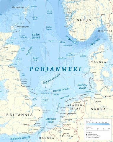
Suomi: Suomenkielinen Pohjanmeren kartta.
English: Map of the North Sea in Finnish. |
| Ceann-là | |
| Tùs |
M’ obair fhèin using GRASS GIS, Inkscape and GIMP. Data sources:
Map projection: Universal Transverse Mercator Typeface: Gentium Book Basic from SIL International |
| Ùghdar | Halava |
| Other versions |
  |
Ceadachadh
I, the copyright holder of this work, hereby publish it under the following licenses:
Tha am faidhle seo fo cheadachas Creative Commons Attribution-Share Alike 3.0 Unported.
- Faodaidh tu:
- a cho-roinneadh – lethbhreac a dhèanamh dhen obair, a sgaoileadh is a tar-chur
- ath-mheasgachadh – an obair atharrachadh
- Fo bhuaidh nan cumhaichean a leanas:
- urram – Feumaidh tu iomradh a thoirt air an ùghdar no an neach aig a bheil cead air, dìreach mar a thoill iad (ach chan ann air dòigh a chuireas an sùilean dhaoine gu bheil iad ag aontachadh riut no ri d’ obair).
- co-roinneadh co-ionnann – Ma dh’atharraicheas tu no ma leasaicheas tu an obair seo, ’s urrainn an tionndadh ùr fon cheadachas seo no fo cheadachas coltach ris.

|
Permission is granted to copy, distribute and/or modify this document under the terms of the GNU Free Documentation License, Version 1.2 or any later version published by the Free Software Foundation; with no Invariant Sections, no Front-Cover Texts, and no Back-Cover Texts. A copy of the license is included in the section entitled GNU Free Documentation License. |
’S urrainn dhut an ceadachas as fhearr leat a thaghadh.
| Annotations | This image is annotated: View the annotations at Commons |
Eachdraidh an fhaidhle
Briog air ceann-là/àm gus am faidhle a shealltainn mar a nochd e aig an àm sin.
| Ceann-là/Àm | Dealbhag | Meud | Cleachdaiche | Beachd | |
|---|---|---|---|---|---|
| làithreach | 15:00, 15 dhen Dàmhair 2010 | | 2,475 × 3,100 (3.84 MB) | Halava | New place names |
| 17:45, 12 dhen Dàmhair 2010 |  | 2,475 × 3,100 (3.83 MB) | Halava | Some corrections; several new place names | |
| 11:19, 12 dhen Dàmhair 2010 |  | 2,475 × 3,100 (3.82 MB) | Halava | Minor corrections; improved legibility; Horns Rev | |
| 08:37, 10 dhen Dàmhair 2010 |  | 2,475 × 3,100 (3.75 MB) | Halava | Exclusive economic zones; Heligoland | |
| 09:21, 9 dhen Dàmhair 2010 |  | 2,475 × 3,100 (3.68 MB) | Halava | Lindisfarne; Norfolk Banks instead of Wells Bank | |
| 20:42, 8 dhen Dàmhair 2010 |  | 2,475 × 3,100 (3.67 MB) | Halava | Outlined Dogger Bank, fixed two typos | |
| 17:07, 8 dhen Dàmhair 2010 |  | 2,475 × 3,100 (3.65 MB) | Halava | Several improvements | |
| 11:13, 6 dhen Dàmhair 2010 |  | 2,475 × 3,100 (3.41 MB) | Halava | Switched color model back to RGB | |
| 09:57, 6 dhen Dàmhair 2010 |  | 2,475 × 3,100 (2.7 MB) | Halava | Fixed scale, indexed colors (reduced size) | |
| 19:12, 5 dhen Dàmhair 2010 |  | 2,475 × 3,100 (3.39 MB) | Halava | {{Information |Description={{fi|1=Suomenkielinen Pohjanmeren kartta.}} {{en|1=Map of North Sea in Finnish.}} |Source={{own}} using GRASS GIS, Inkscape and GIMP. Data sources: * Elevation and bathymetry data from NGDC ETOPO1 * Coastlines, rivers and borde |
Cleachdadh an fhaidhle
Tha ceangal ris an fhaidhle seo san duilleag a leanas:
Cleachdadh fhaidhlichean uile-choitcheann
Tha na uicidhean eile a leanas a’ cleachdadh an fhaidhle seo
- Cleachdadh air fi.wikipedia.org
- Cleachdadh air smn.wikipedia.org
- Cleachdadh air www.wikidata.org