Faidhle:Mount Rainier 7431.JPG

Meud an ro-sheallaidh seo: 800 × 600 piogsail. Dùmhlachdan-breacaidh eile: 320 × 240 piogsail | 640 × 480 piogsail | 1,024 × 768 piogsail | 1,280 × 960 piogsail | 1,600 × 1,200 piogsail.
Am faidhle tùsail (1,600 × 1,200 pixel, meud an fhaidhle: 498 KB, seòrsa MIME: image/jpeg)
Gearr-chunntas
| Tuairisgeul |
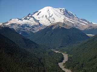
English: Mount Rainier with its main summit, Columbia Crest (14410 feet) at the center. Liberty Cap (14112 feet) is to the right behind Russell Cliff. Curtis Ridge descends to the right from Russell Cliff. Massive Emmons Glacier covers most of the visible flank of the mountain. Winthrop Glacier flows right along Curtis Ridge and behind shallow Steamboat Prow (9680 feet) with the small Inter Glacier on its northeast face. Ingraham Glacier (left) is between Gibralter Rock (12660 feet) high on the left skyline and Disappointment Cleaver. Left of Gibralter Rock is sharp pointed Little Tahoma (11138 feet) with Frying Pan Glacier on its flank. It is the source of Frying Pan Creek in the valley left of forested and rounded Goat Island Mountain, in front of the Emmons Glacier. It flows into the White River which comes from the Emmons Glacier and flows around the right side of Goat Island Mountain. |
| Ceann-là | 25 dhen t-Sultain 2005, 11:26:02 −07:00 |
| Tùs | M’ obair fhèin |
| Ùghdar | Walter Siegmund (talk) |
| Camera location | | View this and other nearby images on: OpenStreetMap |
|---|
- Location Datum: WGS84/NAD83
- Viewpoint location: Crystal Peak Trail, Mount Rainier National Park
- Viewpoint elevation: 5000 foot (1524 m)
- View direction: West-southwest
- Camera: Canon Canon PowerShot S110
- Exposure Time: 1/320
- F Number: f/10.0
- Focal Length: 10.8
- Focal Length In 35mm Film:
- Flash: No
- ISO Speed Rating:
©2006 Walter Siegmund
Ceadachadh
I, the copyright holder of this work, hereby publish it under the following licenses:

|
Permission is granted to copy, distribute and/or modify this document under the terms of the GNU Free Documentation License, Version 1.2 or any later version published by the Free Software Foundation; with no Invariant Sections, no Front-Cover Texts, and no Back-Cover Texts. A copy of the license is included in the section entitled GNU Free Documentation License. |
| Tha am faidhle seo fo cheadachas Creative Commons Attribution-Share Alike 3.0 Unported. | ||
| ||
| This licensing tag was added to this file as part of the GFDL licensing update. |
This file is licensed under the Creative Commons Attribution 2.5 Generic license.
- Faodaidh tu:
- a cho-roinneadh – lethbhreac a dhèanamh dhen obair, a sgaoileadh is a tar-chur
- ath-mheasgachadh – an obair atharrachadh
- Fo bhuaidh nan cumhaichean a leanas:
- urram – Feumaidh tu iomradh a thoirt air an ùghdar no an neach aig a bheil cead air, dìreach mar a thoill iad (ach chan ann air dòigh a chuireas an sùilean dhaoine gu bheil iad ag aontachadh riut no ri d’ obair).
’S urrainn dhut an ceadachas as fhearr leat a thaghadh.
Eachdraidh an fhaidhle
Briog air ceann-là/àm gus am faidhle a shealltainn mar a nochd e aig an àm sin.
| Ceann-là/Àm | Dealbhag | Meud | Cleachdaiche | Beachd | |
|---|---|---|---|---|---|
| làithreach | 21:37, 9 dhen Ghiblean 2008 | | 1,600 × 1,200 (498 KB) | Wsiegmund | Photoshop Elements Autosmartfix and Autocolorcorrection tools |
| 18:18, 5 dhen Mhàrt 2006 |  | 1,600 × 1,200 (316 KB) | Wsiegmund | ||
| 03:50, 13 dhen Ghearran 2006 |  | 1,600 × 1,200 (433 KB) | Wsiegmund | '''Mount Rainier''' * '''Description:''' Mount Rainier with its main summit, Columbia Crest (14410 feet) at the center. Liberty Cap (14112 feet) is to the right behind Russell Cliff. Curtis Ridge descends to the right from Russell Cliff. Massive Emmons Gl |
Cleachdadh an fhaidhle
Tha ceangal ris an fhaidhle seo san duilleag a leanas:
Cleachdadh fhaidhlichean uile-choitcheann
Tha na uicidhean eile a leanas a’ cleachdadh an fhaidhle seo
- Cleachdadh air en.wikipedia.org
- Cleachdadh air fi.wikipedia.org
- Cleachdadh air fr.wikipedia.org
- Cleachdadh air he.wikipedia.org
- Cleachdadh air ja.wikipedia.org
- Cleachdadh air mk.wikipedia.org
- Cleachdadh air ru.wikivoyage.org
- Cleachdadh air ur.wikipedia.org