Faidhle:Mauritius rel90.jpg

Meud an ro-sheallaidh seo: 497 × 599 piogsail. Dùmhlachdan-breacaidh eile: 199 × 240 piogsail | 398 × 480 piogsail | 1,000 × 1,206 piogsail.
Am faidhle tùsail (1,000 × 1,206 pixel, meud an fhaidhle: 236 KB, seòrsa MIME: image/jpeg)
Gearr-chunntas
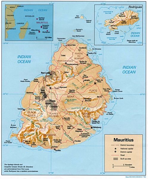
| Tuairisgeul | Relief map of Mauritius, with inset of Rodrigues Island. US Central Intelligence Agency, 1990. |
| Ceann-là | |
| Tùs | University of Texas Libraries, Perry-Castañeda Library Map Collection: Mauritius Maps |
| Ùghdar | CIA |
Ceadachadh
| This image is a work of a Central Intelligence Agency employee, taken or made as part of that person's official duties. As a Work of the United States Government, this image or media is in the public domain in the United States.
|

|
Eachdraidh an fhaidhle
Briog air ceann-là/àm gus am faidhle a shealltainn mar a nochd e aig an àm sin.
| Ceann-là/Àm | Dealbhag | Meud | Cleachdaiche | Beachd | |
|---|---|---|---|---|---|
| làithreach | 22:31, 11 dhen Dùbhlachd 2006 | | 1,000 × 1,206 (236 KB) | Electionworld | {{ew|en|Tom Radulovich}} {{PD-USGov-CIA}} Relief map of {{link|Mauritius}}, with inset of Rodrigues Island. US Central Intelligence Agency, 1990. |
Cleachdadh an fhaidhle
Tha ceangal ris an fhaidhle seo sna duilleagan a leanas:
Cleachdadh fhaidhlichean uile-choitcheann
Tha na uicidhean eile a leanas a’ cleachdadh an fhaidhle seo
- Cleachdadh air fr.wikipedia.org
- Cleachdadh air hr.wiktionary.org
- Cleachdadh air ht.wikipedia.org
- Cleachdadh air ru.wikipedia.org
- Cleachdadh air sr.wikipedia.org
- Cleachdadh air uk.wikipedia.org
- Cleachdadh air vec.wikipedia.org
- Cleachdadh air vep.wikipedia.org
- Cleachdadh air www.wikidata.org
- Cleachdadh air yo.wikipedia.org
- Cleachdadh air zh.wikipedia.org