Faidhle:Karte des Deutschen Reiches, Weimarer Republik-Drittes Reich 1919–1937.svg

Size of this PNG preview of this SVG file: 660 × 600 piogsail. Dùmhlachdan-breacaidh eile: 264 × 240 piogsail | 528 × 480 piogsail | 845 × 768 piogsail | 1,127 × 1,024 piogsail | 2,254 × 2,048 piogsail | 974 × 885 piogsail.
Am faidhle tùsail (Faidhle SVG, a-rèir ainm 974 × 885 pixel, meud faidhle: 1.7 MB)
Gearr-chunntas
| Tuairisgeul |
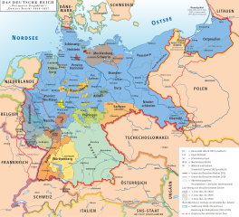
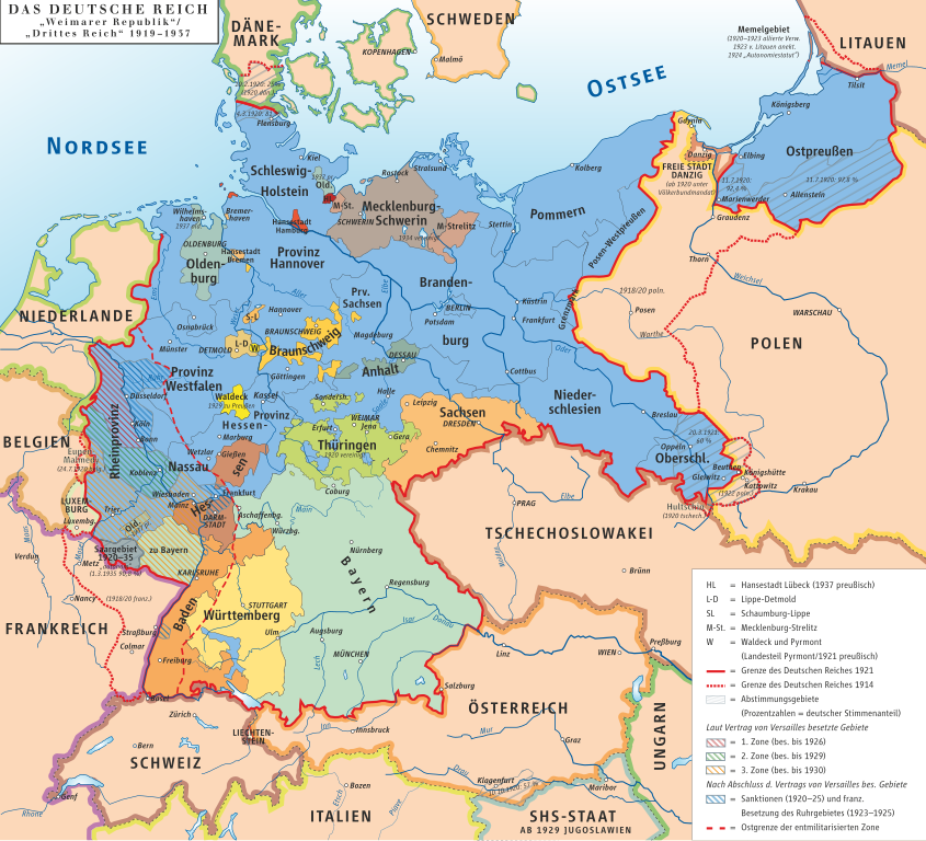
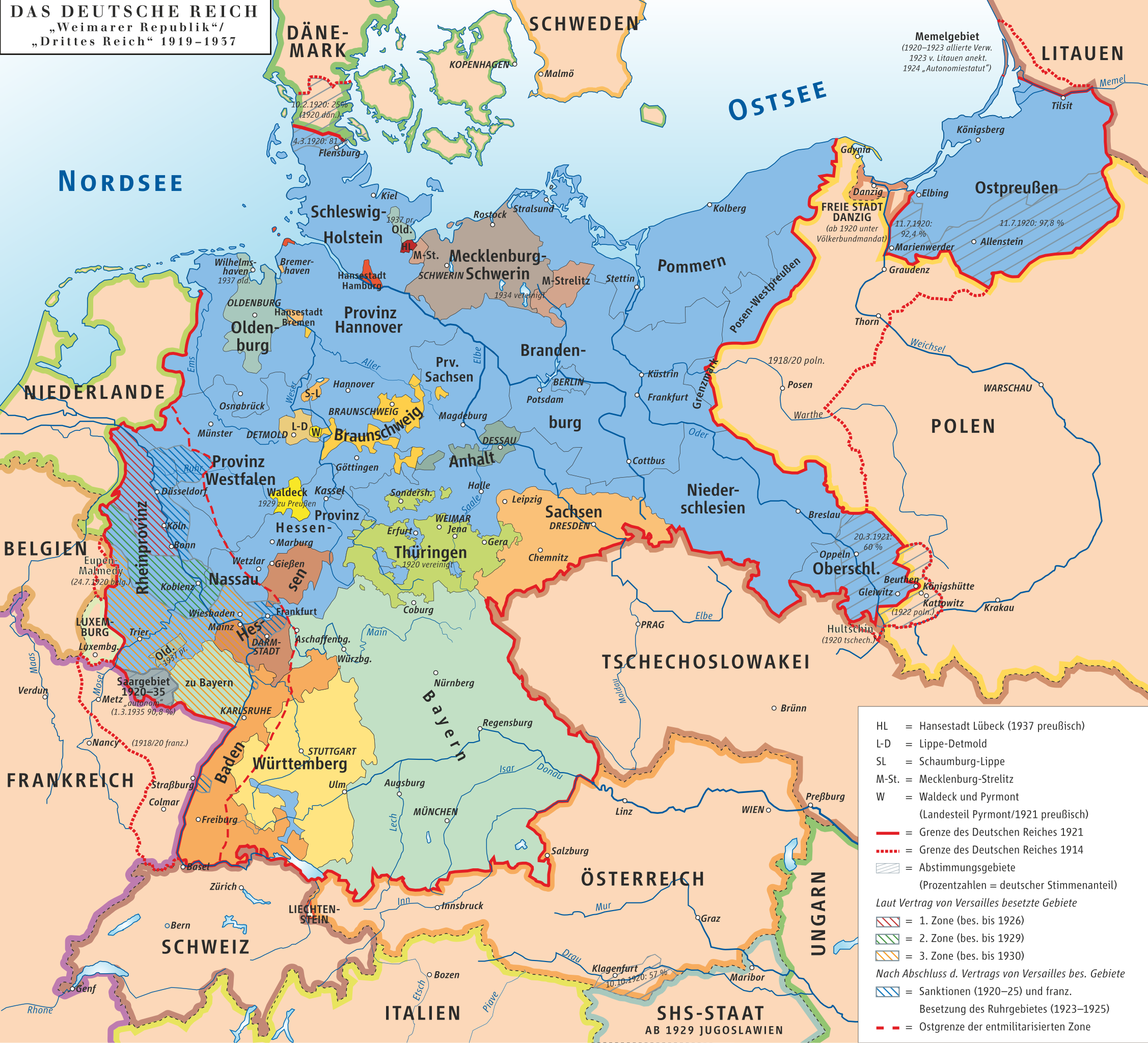
Deutsch: Karte des Deutschen Reiches, »Weimarer Republik/Drittes Reich« 1919–1937 English: Map of the German Reich, (Republic of Weimar/Third Reich) 1919–1937 |
| Ceann-là | |
| Tùs | own drawing/Source of Information: Putzger – Historischer Weltatlas, 89. Auflage, 1965 |
| Ùghdar | kgberger |
| Cead (Ag ath-chleachdadh an fhaidhle seo) |
GNU FDL |
| SVG genesis |
Ceadachadh
I, the copyright holder of this work, hereby publish it under the following licenses:

|
Permission is granted to copy, distribute and/or modify this document under the terms of the GNU Free Documentation License, Version 1.2 or any later version published by the Free Software Foundation; with no Invariant Sections, no Front-Cover Texts, and no Back-Cover Texts. A copy of the license is included in the section entitled GNU Free Documentation License. |
| Tha am faidhle seo fo cheadachas Creative Commons Attribution-Share Alike 3.0 Unported. | ||
| ||
| This licensing tag was added to this file as part of the GFDL licensing update. |
This file is licensed under the Creative Commons Attribution 2.5 Generic license.
- Faodaidh tu:
- a cho-roinneadh – lethbhreac a dhèanamh dhen obair, a sgaoileadh is a tar-chur
- ath-mheasgachadh – an obair atharrachadh
- Fo bhuaidh nan cumhaichean a leanas:
- urram – Feumaidh tu iomradh a thoirt air an ùghdar no an neach aig a bheil cead air, dìreach mar a thoill iad (ach chan ann air dòigh a chuireas an sùilean dhaoine gu bheil iad ag aontachadh riut no ri d’ obair).
’S urrainn dhut an ceadachas as fhearr leat a thaghadh.
Eachdraidh an fhaidhle
Briog air ceann-là/àm gus am faidhle a shealltainn mar a nochd e aig an àm sin.
| Ceann-là/Àm | Dealbhag | Meud | Cleachdaiche | Beachd | |
|---|---|---|---|---|---|
| làithreach | 20:17, 21 dhen Fhaoilleach 2023 | | 974 × 885 (1.7 MB) | Felicior | move Freiburg further to the east |
| 11:22, 13 dhen Dùbhlachd 2020 |  | 974 × 885 (1.45 MB) | Intforce | Reduce SVG file size | |
| 12:30, 9 dhen Fhaoilleach 2013 |  | 974 × 885 (2.06 MB) | Ziegelbrenner | 2013-01-09 | |
| 16:34, 27 dhen Iuchar 2010 |  | 775 × 775 (1.07 MB) | Beao | Tweak. | |
| 16:31, 27 dhen Iuchar 2010 |  | 779 × 782 (1.07 MB) | Beao | Removed border. | |
| 16:37, 7 dhen t-Samhain 2008 |  | 782 × 784 (1,002 KB) | Ahellwig | test | |
| 16:24, 7 dhen t-Samhain 2008 | Gun dealbhag | (1,003 KB) | ChrisiPK | Reverted to version as of 12:35, 18 January 2008: new version seems to be broken | |
| 12:37, 18 dhen Fhaoilleach 2008 | Gun dealbhag | (1,003 KB) | Ziegelbrenner | == Beschreibung == {{Information |Description=Karte des Deutschen Reiches, »Weimarer Republik/Drittes Reich« 1919–1937 / Map of German Reich, »Republic of Weimar/Third Reich« 1919–1937 |Source=own drawing/Source of Information: Putzger – Histori | |
| 12:35, 18 dhen Fhaoilleach 2008 | Gun dealbhag | (1,003 KB) | Ziegelbrenner | == Beschreibung == {{Information |Description=Karte des Deutschen Reiches, »Weimarer Republik/Drittes Reich« 1919–1937 / Map of German Reich, »Republic of Weimar/Third Reich« 1919–1937 |Source=own drawing/Source of Information: Putzger – Histori |
Cleachdadh an fhaidhle
Tha ceangal ris an fhaidhle seo san duilleag a leanas:
Cleachdadh fhaidhlichean uile-choitcheann
Tha na uicidhean eile a leanas a’ cleachdadh an fhaidhle seo
- Cleachdadh air af.wikipedia.org
- Cleachdadh air als.wikipedia.org
- Cleachdadh air an.wikipedia.org
- Cleachdadh air ar.wikipedia.org
- تورينغن
- ولاية بريمن
- بافاريا
- ساكسونيا
- بروسيا
- جمهورية فايمار
- جمهورية عنق الزجاجة
- قالب:ولايات جمهورية فايمار
- ولاية بروسيا الحرة
- بوابة:بافاريا
- بوابة:بافاريا/قوالب
- ولاية أنهالت الحرة
- الرايخ الرابع
- مستخدم:Marksman003/قائمة بشعارات النبالة في ألمانيا
- قائمة الولايات التاريخية الألمانية
- التقسيمات الإدارية في ألمانيا النازية
- جمهورية بافاريا السوفيتية
- ولاية بافاريا الشعبية
- Cleachdadh air ast.wikipedia.org
- Cleachdadh air azb.wikipedia.org
- Cleachdadh air ba.wikipedia.org
- Cleachdadh air be-tarask.wikipedia.org
- Cleachdadh air be.wikipedia.org
- Cleachdadh air bg.wikipedia.org
- Cleachdadh air bn.wikipedia.org
- Cleachdadh air bs.wikipedia.org
- Cleachdadh air ca.wikipedia.org
- Cleachdadh air cs.wikipedia.org
- Cleachdadh air da.wikipedia.org
- Cleachdadh air de.wikipedia.org
Seall an corr dhen chleachdadh uile-choitcheann a nithear dhen fhaidhle seo.