Faidhle:GuineaMap.png
Chan eil dùmhlachd-bhreacaidh nas fhearr ri fhaighinn.
GuineaMap.png (325 × 350 pixel, meud an fhaidhle: 11 KB, seòrsa MIME: image/png)
Gearr-chunntas
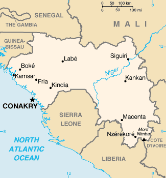
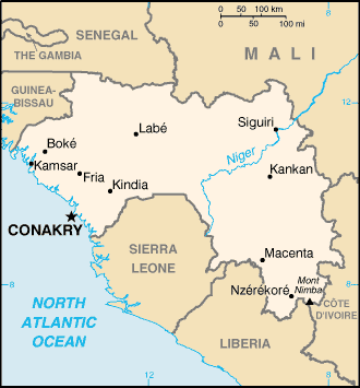
| Tuairisgeul | Map of Guinea, U.S. Central Intelligence Agency World Factbook map, 2002. |
| Ceann-là | |
| Tùs | University of Texas Libraries, Perry-Castañeda Library Map Collection: CIA World Factbook 2002 - Country Maps |
| Ùghdar | CIA |
Ceadachadh
| This image is a work of a Central Intelligence Agency employee, taken or made as part of that person's official duties. As a Work of the United States Government, this image or media is in the public domain in the United States.
|

|
Eachdraidh an fhaidhle
Briog air ceann-là/àm gus am faidhle a shealltainn mar a nochd e aig an àm sin.
| Ceann-là/Àm | Dealbhag | Meud | Cleachdaiche | Beachd | |
|---|---|---|---|---|---|
| làithreach | 00:41, 31 dhen Dàmhair 2021 | | 325 × 350 (11 KB) | Lojwe | Cropped 2 % horizontally, 1 % vertically using CropTool with precise mode. |
| 04:21, 8 dhen t-Sultain 2007 |  | 330 × 355 (11 KB) | BetacommandBot | Transwiki approved by: w:en:User:Dmcdevit This image was copied from wikipedia:en. The original description was: Map of Guinea Adapted from [http://www.lib.utexas.edu/maps/index.html PCL map collection] {{PD-USGov-CIA}} === File history === {| cl |
Cleachdadh an fhaidhle
Tha ceangal ris an fhaidhle seo san duilleag a leanas:
Cleachdadh fhaidhlichean uile-choitcheann
Tha na uicidhean eile a leanas a’ cleachdadh an fhaidhle seo
- Cleachdadh air az.wiktionary.org
- Cleachdadh air be-tarask.wikipedia.org
- Cleachdadh air bjn.wikipedia.org
- Cleachdadh air eo.wikipedia.org
- Cleachdadh air es.wikipedia.org
- Cleachdadh air id.wikipedia.org
- Cleachdadh air it.wikipedia.org
- Cleachdadh air mk.wikipedia.org
- Cleachdadh air ms.wikipedia.org
- Cleachdadh air ro.wikipedia.org
- Cleachdadh air sg.wikipedia.org
- Cleachdadh air sg.wiktionary.org
- Cleachdadh air simple.wikipedia.org
- Cleachdadh air sw.wikipedia.org
- Cleachdadh air tr.wiktionary.org
- Cleachdadh air vec.wikipedia.org
- Cleachdadh air vi.wikipedia.org
- Cleachdadh air wo.wikipedia.org