Faidhle:Carte de la Manche.png

Meud an ro-sheallaidh seo: 800 × 447 piogsail. Dùmhlachdan-breacaidh eile: 320 × 179 piogsail | 832 × 465 piogsail.
Am faidhle tùsail (832 × 465 pixel, meud an fhaidhle: 107 KB, seòrsa MIME: image/png)
Gearr-chunntas
| Tuairisgeul |
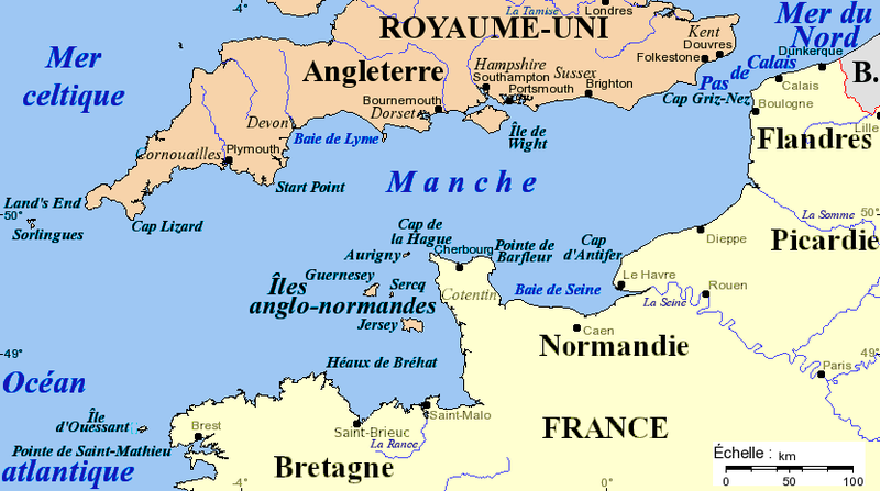
Français : Carte de la Manche avec la situation des caps principaux, des îles et des villes importantes. Projection de Mercator, données de 2005. Fond de carte provenant de [www.aquarius.geomar.de www.aquarius.geomar.de] (défunt).
English: Channel map with main capes, islands and cities. Projection of Mercator, data as of 2005. Map background from [www.aquarius.geomar.de www.aquarius.geomar.de] (defunct). |
| Ceann-là | 4 dhen Ògmhios 2005, 16:52 (original upload date) |
| Tùs | M’ obair fhèin |
| Ùghdar | Idarvol (deasbaireachd · mùthaidhean) |

|
This map image could be re-created using vector graphics as an SVG file. This has several advantages; see Commons:Media for cleanup for more information. If an SVG form of this image is available, please upload it and afterwards replace this template with
{{vector version available|new image name}}.
It is recommended to name the SVG file “Carte de la Manche.svg”—then the template Vector version available (or Vva) does not need the new image name parameter. |
Ceadachadh
I, the copyright holder of this work, hereby publish it under the following license:

|
Permission is granted to copy, distribute and/or modify this document under the terms of the GNU Free Documentation License, Version 1.2 or any later version published by the Free Software Foundation; with no Invariant Sections, no Front-Cover Texts, and no Back-Cover Texts. A copy of the license is included in the section entitled GNU Free Documentation License. |
| Tha am faidhle seo fo cheadachas Creative Commons Attribution-Share Alike 3.0 Unported. | ||
| ||
| This licensing tag was added to this file as part of the GFDL licensing update. |
Eachdraidh an fhaidhle
Briog air ceann-là/àm gus am faidhle a shealltainn mar a nochd e aig an àm sin.
| Ceann-là/Àm | Dealbhag | Meud | Cleachdaiche | Beachd | |
|---|---|---|---|---|---|
| làithreach | 17:19, 16 dhen t-Samhain 2020 | | 832 × 465 (107 KB) | Hohum | Cartographic colours |
| 02:40, 3 dhen Ghearran 2016 |  | 832 × 465 (99 KB) | Ptyx | Ouesssant > Ouessant | |
| 17:31, 15 dhen Ghearran 2011 |  | 832 × 465 (71 KB) | Mahahahaneapneap | Compressed | |
| 16:52, 4 dhen Ògmhios 2005 |  | 832 × 465 (105 KB) | Idarvol | Carte de la Manche. |
Cleachdadh an fhaidhle
Tha ceangal ris an fhaidhle seo san duilleag a leanas:
Cleachdadh fhaidhlichean uile-choitcheann
Tha na uicidhean eile a leanas a’ cleachdadh an fhaidhle seo
- Cleachdadh air af.wikipedia.org
- Cleachdadh air br.wikipedia.org
- Cleachdadh air bs.wikipedia.org
- Cleachdadh air ca.wikipedia.org
- Cleachdadh air cs.wikipedia.org
- Cleachdadh air de.wikipedia.org
- Cleachdadh air en.wikipedia.org
- Cleachdadh air es.wikipedia.org
- Cleachdadh air fr.wikipedia.org
- Cleachdadh air fr.wiktionary.org
- Cleachdadh air hi.wikipedia.org
- Cleachdadh air ja.wikipedia.org
- Cleachdadh air ka.wikipedia.org
- Cleachdadh air kw.wikipedia.org
- Cleachdadh air pa.wikipedia.org
- Cleachdadh air pl.wiktionary.org
- Cleachdadh air scn.wikipedia.org
- Cleachdadh air sr.wikipedia.org
- Cleachdadh air xmf.wikipedia.org
- Cleachdadh air zh.wikipedia.org