Faidhle:British isles 802.jpg
Meud an ro-sheallaidh seo: 572 × 599 piogsail. Dùmhlachdan-breacaidh eile: 229 × 240 piogsail | 458 × 480 piogsail | 733 × 768 piogsail | 1,076 × 1,127 piogsail.
Am faidhle tùsail (1,076 × 1,127 pixel, meud an fhaidhle: 1.29 MB, seòrsa MIME: image/jpeg)
Gearr-chunntas
| Tuairisgeul |
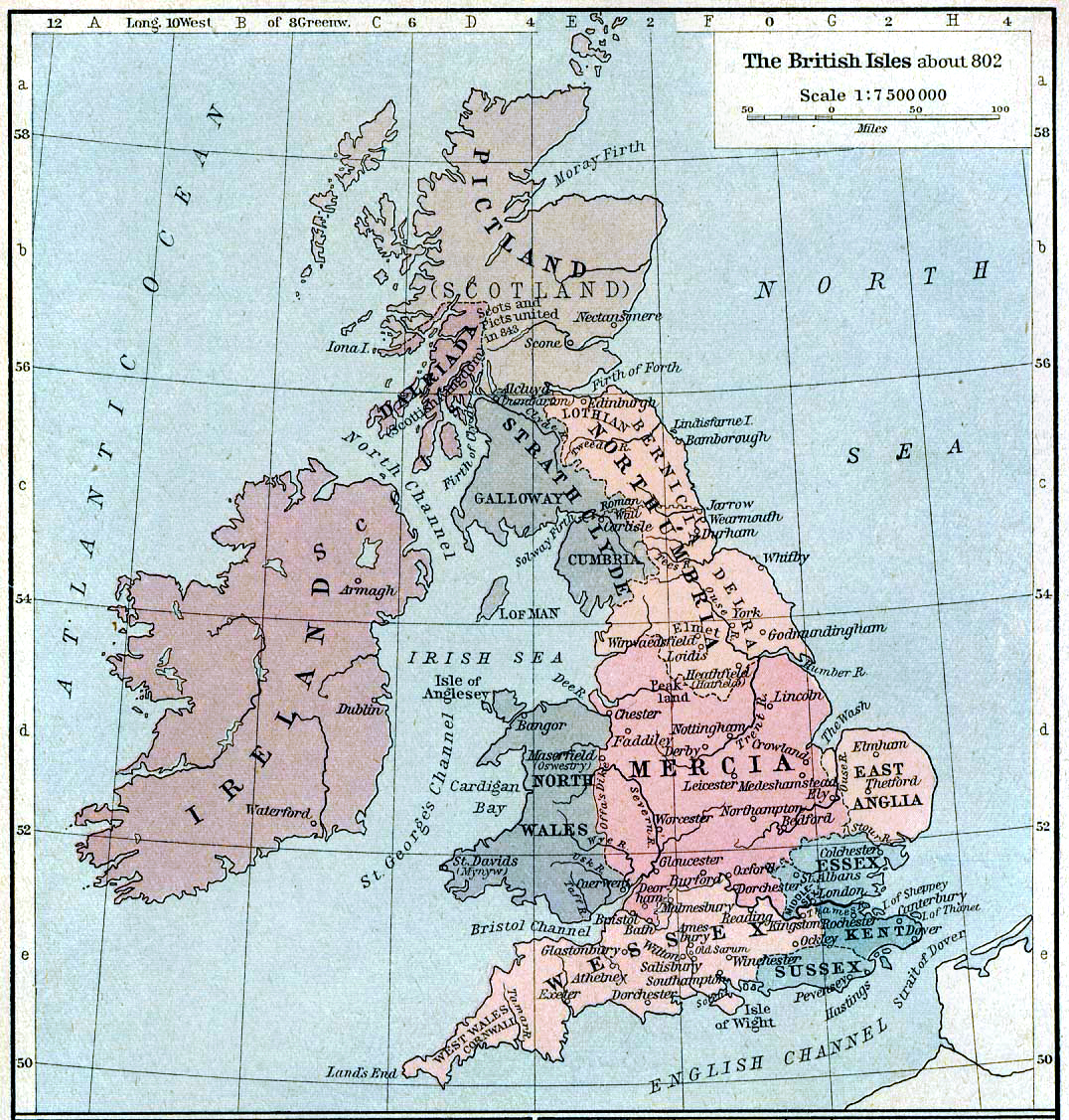
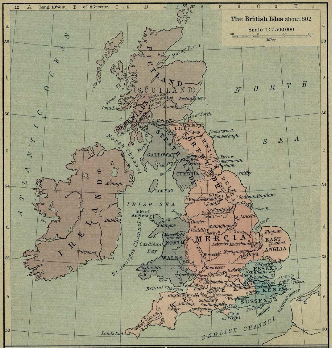
English: Map of the British Isles claiming to represent borders circa 802 AD. |
||||||||||||||||||||||
| Ceann-là | |||||||||||||||||||||||
| Tùs | Shepherd, William R. (1926) Historical Atlas, Category:New York: Henry Holt and Company | ||||||||||||||||||||||
| Ùghdar |
|
||||||||||||||||||||||
Ceadachadh
|
The author died in 1934, so this work is in the public domain in its country of origin and other countries and areas where the copyright term is the author's life plus 80 years or fewer. This work is in the public domain in the United States because it was published (or registered with the U.S. Copyright Office) before January 1, 1929. | |
| This file has been identified as being free of known restrictions under copyright law, including all related and neighboring rights. | |
Eachdraidh an fhaidhle
Briog air ceann-là/àm gus am faidhle a shealltainn mar a nochd e aig an àm sin.
| Ceann-là/Àm | Dealbhag | Meud | Cleachdaiche | Beachd | |
|---|---|---|---|---|---|
| làithreach | 21:30, 12 dhen Lùnastal 2019 | | 1,076 × 1,127 (1.29 MB) | Alphathon | A few more minor tweaks |
| 21:24, 12 dhen Lùnastal 2019 |  | 1,076 × 1,127 (1.24 MB) | Alphathon | re-did cleaning (using original version) | |
| 18:36, 8 dhen Dàmhair 2006 |  | 1,076 × 1,127 (1.19 MB) | Steinsky | cleaned | |
| 15:47, 3 dhen Dùbhlachd 2005 |  | 1,076 × 1,127 (273 KB) | Migdejong | Map of the isle Great Brittain in the year 802. Image comes from the University of Texas at Austin: http://geography.about.com/gi/dynamic/offsite.htm?site=http://www.lib.utexas.edu/maps/historical/history%5Feurope.html Map is released into the publi |
Cleachdadh an fhaidhle
Tha ceangal ris an fhaidhle seo san duilleag a leanas:
Cleachdadh fhaidhlichean uile-choitcheann
Tha na uicidhean eile a leanas a’ cleachdadh an fhaidhle seo
- Cleachdadh air be-tarask.wikipedia.org
- Cleachdadh air be.wikipedia.org
- Cleachdadh air br.wikipedia.org
- Cleachdadh air de.wikipedia.org
- Cleachdadh air el.wikipedia.org
- Cleachdadh air en.wikipedia.org
- List of monarchs of East Anglia
- Talk:East Anglia
- List of monarchs of Wessex
- List of monarchs of Northumbria
- List of monarchs of Mercia
- List of monarchs of Kent
- List of monarchs of Sussex
- History of Cornwall
- Constitutional status of Cornwall
- Talk:Regions of England
- Wikipedia:WikiProject Anglo-Saxon Kingdoms
- User:Amitchell125/listofmonarchsofeastanglia
- Template:Anglo-Saxon kings
- Cleachdadh air fr.wikipedia.org
- Cleachdadh air got.wikipedia.org
- Cleachdadh air he.wikipedia.org
- Cleachdadh air hu.wikipedia.org
- Cleachdadh air it.wikipedia.org
Seall an corr dhen chleachdadh uile-choitcheann a nithear dhen fhaidhle seo.