Faidhle:Boreray Coastal View - geograph.org.uk - 1379935.jpg
Chan eil dùmhlachd-bhreacaidh nas fhearr ri fhaighinn.
Boreray_Coastal_View_-_geograph.org.uk_-_1379935.jpg (640 × 344 pixel, meud an fhaidhle: 39 KB, seòrsa MIME: image/jpeg)
Gearr-chunntas
| Tuairisgeul |
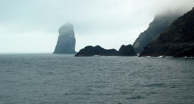
English: Boreray Coastal View The island of Sgarbhstac and the rocky point of Gob Scapanais lie inside the square. Stac Lee is shown in the background. Every September, the St Kildans would undertake the dangerous task of hunting the young Gannets, or Gugas, on Boreray and its two great stacks. They had to climb the steep cliffs, barefoot, at night. The night's kill was thrown into the sea for the boat to collect, with some birds left in cleits as a food supply for the next expedition to the island. Women climbed Boreray too, and could carry a sheep or lambs while doing so. (Source: "The Life and Death of St Kilda", by Tom Steel) |
| Ceann-là | |
| Tùs | From geograph.org.uk |
| Ùghdar | Mary and Angus Hogg |
| Urram (required by the license) | Mary and Angus Hogg / Boreray Coastal View / |
| Camera location | | View this and other nearby images on: OpenStreetMap |
|---|
_heading:292.00&language=gd)
| Object location | | View this and other nearby images on: OpenStreetMap |
|---|
_heading:292.00&language=gd)
Ceadachadh

|
This image was taken from the Geograph project collection. See this photograph's page on the Geograph website for the photographer's contact details. The copyright on this image is owned by Mary and Angus Hogg and is licensed for reuse under the Creative Commons Attribution-ShareAlike 2.0 license.
|
This file is licensed under the Creative Commons Attribution-Share Alike 2.0 Generic license.
Urram: Mary and Angus Hogg
- Faodaidh tu:
- a cho-roinneadh – lethbhreac a dhèanamh dhen obair, a sgaoileadh is a tar-chur
- ath-mheasgachadh – an obair atharrachadh
- Fo bhuaidh nan cumhaichean a leanas:
- urram – Feumaidh tu iomradh a thoirt air an ùghdar no an neach aig a bheil cead air, dìreach mar a thoill iad (ach chan ann air dòigh a chuireas an sùilean dhaoine gu bheil iad ag aontachadh riut no ri d’ obair).
- co-roinneadh co-ionnann – Ma dh’atharraicheas tu no ma leasaicheas tu an obair seo, ’s urrainn an tionndadh ùr fon cheadachas seo no fo cheadachas coltach ris.
Eachdraidh an fhaidhle
Briog air ceann-là/àm gus am faidhle a shealltainn mar a nochd e aig an àm sin.
| Ceann-là/Àm | Dealbhag | Meud | Cleachdaiche | Beachd | |
|---|---|---|---|---|---|
| làithreach | 14:09, 28 dhen Ghearran 2011 | | 640 × 344 (39 KB) | GeographBot | == {{int:filedesc}} == {{Information |description={{en|1=Boreray Coastal View The island of Sgarbhstac and the rocky point of Gob Scapanais lie inside the square. Stac Lee is shown in the background. Every September, the St Kildans would undertake the d |
Cleachdadh an fhaidhle
Tha ceangal ris an fhaidhle seo san duilleag a leanas:
Cleachdadh fhaidhlichean uile-choitcheann
Tha na uicidhean eile a leanas a’ cleachdadh an fhaidhle seo
- Cleachdadh air en.wikipedia.org
- Cleachdadh air fy.wikipedia.org