Faidhle:Basin of Lop Nur 90.25E, 40.10N, Kum Tagh and Astin Tagh.jpg
Chan eil dùmhlachd-bhreacaidh nas fhearr ri fhaighinn.
Basin_of_Lop_Nur_90.25E,_40.10N,_Kum_Tagh_and_Astin_Tagh.jpg (576 × 441 pixel, meud an fhaidhle: 176 KB, seòrsa MIME: image/jpeg)
Gearr-chunntas
| Tuairisgeul |
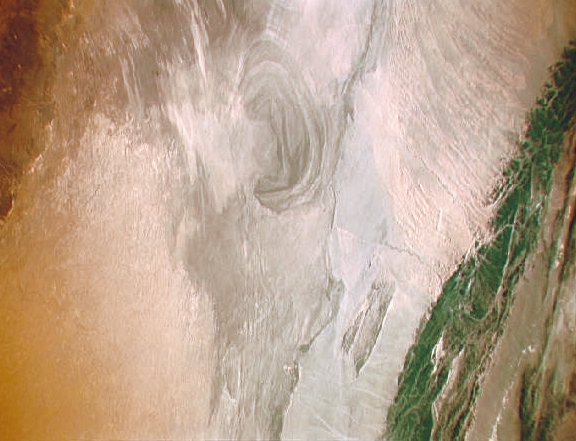
English: China, Xinjiang, desert Lop Nur. Satellite picture of the Basin of the formerly sea Lop Nur in the Desert of Lop Nur. In the foreground Kuruktagh, in the background Kumtagh and Astintagh.
Deutsch: China, Xinjiang, Wüste Lop Nor. Satellitenaufnahme von dem mittleren Teil des Seebeckens Lop Nor und der Wüste Lop Nor. Links im Vordergrund sieht man einen Teil des Gebirges Kuruktagh mit Kratern des Kernwaffentestgeländes, im Hintergrund die Hänge des Kumtagh und die Hochebene des Astintagh. Blick von Nordwesten Richtung Südosten. |
| Ceann-là | 12 dhen t-Sultain 1992 - 20 dhen t-Sultain 1992 |
| Tùs | NASA Mission: STS047 Roll: 217 Frame: 33 Mission ID on the Film or image: STS47. File name: STS047-217-33.JPG [1] |
| Ùghdar | NASA. Color adjusting of this image (using Adobe Photoshop 6.0): Michael Gaebler, 02. March 2006, own work, all rights released (Public domain). de: Zugrunde liegt ein noch nicht farbrichtiges Astronauten-Foto der NASA. Diese Fotografie wurde von Michael Gaebler am 02. März 2006 im RGB-Modus mit Adobe Photoshop 6.0 mit Farb- und Tonwertkorrekturen überarbeitet. |
| Cead (Ag ath-chleachdadh an fhaidhle seo) |
PD-USGov-NASA |
This image or video was catalogued by one of the centers of the United States National Aeronautics and Space Administration (NASA) under Photo ID: STS047-217-33. This tag does not indicate the copyright status of the attached work. A normal copyright tag is still required. See Commons:Licensing. Other languages:
|
Ceadachadh
| This file is in the public domain in the United States because it was solely created by NASA. NASA copyright policy states that "NASA material is not protected by copyright unless noted". (See Template:PD-USGov, NASA copyright policy page or JPL Image Use Policy.) | ||
 |
Warnings:
|
Eachdraidh an fhaidhle
Briog air ceann-là/àm gus am faidhle a shealltainn mar a nochd e aig an àm sin.
| Ceann-là/Àm | Dealbhag | Meud | Cleachdaiche | Beachd | |
|---|---|---|---|---|---|
| làithreach | 15:57, 23 dhen Dùbhlachd 2012 | | 576 × 441 (176 KB) | Rotatebot | Bot: Image rotated by 90° |
| 00:42, 6 dhen Mhàrt 2006 |  | 441 × 585 (178 KB) | Michael Gäbler | {{Information| |Description = en: China, Xinjiang, desert Lop Nur. Satellite picture of the Basin of the formerly sea Lop Nur in the desert of Lop. In the foreground Kuruktagh, in the background Kumtagh and Astintagh. de: China, Xinjiang, W� |
Cleachdadh an fhaidhle
Tha ceangal ris an fhaidhle seo san duilleag a leanas:
Cleachdadh fhaidhlichean uile-choitcheann
Tha na uicidhean eile a leanas a’ cleachdadh an fhaidhle seo
- Cleachdadh air ar.wikipedia.org
- Cleachdadh air az.wikipedia.org
- Cleachdadh air bg.wikipedia.org
- Cleachdadh air ca.wikipedia.org
- Cleachdadh air de.wikipedia.org
- Cleachdadh air en.wikipedia.org
- Cleachdadh air en.wikivoyage.org
- Cleachdadh air eo.wikipedia.org
- Cleachdadh air es.wikipedia.org
- Cleachdadh air es.wikivoyage.org
- Cleachdadh air et.wikipedia.org
- Cleachdadh air he.wikipedia.org
- Cleachdadh air he.wikivoyage.org
- Cleachdadh air hi.wikipedia.org
- Cleachdadh air hu.wikipedia.org
- Cleachdadh air hy.wikipedia.org
- Cleachdadh air id.wikipedia.org
- Cleachdadh air it.wikipedia.org
- Cleachdadh air ka.wikipedia.org
- Cleachdadh air kk.wikipedia.org
- Cleachdadh air ko.wikipedia.org
- Cleachdadh air lt.wikipedia.org
- Cleachdadh air mk.wikipedia.org
- Cleachdadh air nl.wikipedia.org
- Cleachdadh air pt.wikipedia.org
- Cleachdadh air ru.wikipedia.org
- Cleachdadh air sh.wikipedia.org
- Cleachdadh air sl.wikipedia.org
- Cleachdadh air te.wikipedia.org
- Cleachdadh air ug.wikipedia.org
- Cleachdadh air www.wikidata.org
- Cleachdadh air zh.wikivoyage.org