Faidhle:Anwoth Old Kirk and Kirkyard - geograph.org.uk - 890377.jpg
Chan eil dùmhlachd-bhreacaidh nas fhearr ri fhaighinn.
Anwoth_Old_Kirk_and_Kirkyard_-_geograph.org.uk_-_890377.jpg (640 × 480 pixel, meud an fhaidhle: 87 KB, seòrsa MIME: image/jpeg)
Gearr-chunntas
| Tuairisgeul |
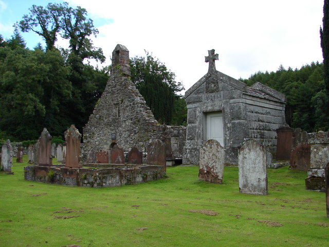
English: Anwoth Old Kirk & Kirkyard The old kirk ruins (1626) retains a medieval bell and has a Samuel Rutherford plaque over the doorway. Interesting gravestones include table stones and a cross-slab. The 2.4m/7.9ft-high granite Gordon mausoleum was built 1878. |
| Ceann-là | |
| Tùs | From geograph.org.uk |
| Ùghdar | Chris Newman |
| Urram (required by the license) | Chris Newman / Anwoth Old Kirk & Kirkyard / |
| Camera location | | View this and other nearby images on: OpenStreetMap |
|---|
_heading:45.00&language=gd)
| Object location | | View this and other nearby images on: OpenStreetMap |
|---|
_heading:45.00&language=gd)
Ceadachadh

|
This image was taken from the Geograph project collection. See this photograph's page on the Geograph website for the photographer's contact details. The copyright on this image is owned by Chris Newman and is licensed for reuse under the Creative Commons Attribution-ShareAlike 2.0 license.
|
This file is licensed under the Creative Commons Attribution-Share Alike 2.0 Generic license.
Urram: Chris Newman
- Faodaidh tu:
- a cho-roinneadh – lethbhreac a dhèanamh dhen obair, a sgaoileadh is a tar-chur
- ath-mheasgachadh – an obair atharrachadh
- Fo bhuaidh nan cumhaichean a leanas:
- urram – Feumaidh tu iomradh a thoirt air an ùghdar no an neach aig a bheil cead air, dìreach mar a thoill iad (ach chan ann air dòigh a chuireas an sùilean dhaoine gu bheil iad ag aontachadh riut no ri d’ obair).
- co-roinneadh co-ionnann – Ma dh’atharraicheas tu no ma leasaicheas tu an obair seo, ’s urrainn an tionndadh ùr fon cheadachas seo no fo cheadachas coltach ris.
Eachdraidh an fhaidhle
Briog air ceann-là/àm gus am faidhle a shealltainn mar a nochd e aig an àm sin.
| Ceann-là/Àm | Dealbhag | Meud | Cleachdaiche | Beachd | |
|---|---|---|---|---|---|
| làithreach | 15:14, 21 dhen Ghearran 2011 | | 640 × 480 (87 KB) | GeographBot | == {{int:filedesc}} == {{Information |description={{en|1=Anwoth Old Kirk & Kirkyard The old kirk ruins (1626) retains a medieval bell and has a Samuel Rutherford plague over the doorway. Interesting gravestones include table stones and a cross-slab. The 2 |
Cleachdadh an fhaidhle
Tha ceangal ris an fhaidhle seo sna duilleagan a leanas:
Cleachdadh fhaidhlichean uile-choitcheann
Tha na uicidhean eile a leanas a’ cleachdadh an fhaidhle seo
- Cleachdadh air de.wikipedia.org
- Cleachdadh air en.wikipedia.org
- Cleachdadh air eu.wikipedia.org
- Cleachdadh air vi.wikipedia.org
- Cleachdadh air www.wikidata.org