Faidhle:Aj-map.png
Chan eil dùmhlachd-bhreacaidh nas fhearr ri fhaighinn.
Aj-map.png (325 × 349 pixel, meud an fhaidhle: 13 KB, seòrsa MIME: image/png)
Gearr-chunntas
| Tuairisgeul |
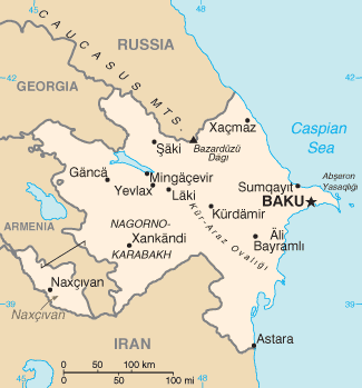
Türkçe: Azerbaycan'ın CIA tarafından oluşturulmuş haritası |
| Ceann-là | |
| Tùs | CIA World Factbook |
| Ùghdar | United States Central Intelligence Agency |
Ceadachadh
This image is in the public domain because it contains materials that originally came from the United States Central Intelligence Agency's World Factbook.
|
 |
Derivative works
Derivative works of this file: Mapa de Azerbaiyán.png
| Annotations | This image is annotated: View the annotations at Commons |
Eachdraidh an fhaidhle
Briog air ceann-là/àm gus am faidhle a shealltainn mar a nochd e aig an àm sin.
| Ceann-là/Àm | Dealbhag | Meud | Cleachdaiche | Beachd | |
|---|---|---|---|---|---|
| làithreach | 07:44, 19 dhen Ghearran 2022 | | 325 × 349 (13 KB) | Lojwe | Cropped 1 % horizontally, 1 % vertically using CropTool with precise mode. |
| 12:44, 5 dhen Lùnastal 2015 |  | 328 × 352 (14 KB) | Ray Garraty | Reverted to version as of 22:26, 26 February 2005 | |
| 12:11, 5 dhen Lùnastal 2015 |  | 328 × 352 (43 KB) | Szczureq | Added border of Armenian-controlled Nagorno-Karabakh territory | |
| 22:26, 26 dhen Ghearran 2005 |  | 328 × 352 (14 KB) | Alfio | Cia map of Azerbaijan |
Cleachdadh an fhaidhle
Tha ceangal ris an fhaidhle seo san duilleag a leanas:
Cleachdadh fhaidhlichean uile-choitcheann
Tha na uicidhean eile a leanas a’ cleachdadh an fhaidhle seo
- Cleachdadh air ab.wikipedia.org
- Cleachdadh air af.wikipedia.org
- Cleachdadh air ast.wikipedia.org
- Cleachdadh air av.wikipedia.org
- Cleachdadh air azb.wikipedia.org
- Cleachdadh air az.wikipedia.org
- Cleachdadh air be-tarask.wikipedia.org
- Cleachdadh air be.wikipedia.org
- Cleachdadh air bg.wikipedia.org
- Cleachdadh air bg.wiktionary.org
- Cleachdadh air br.wikipedia.org
- Cleachdadh air bs.wikipedia.org
- Cleachdadh air ca.wikipedia.org
- Cleachdadh air cs.wikipedia.org
- Cleachdadh air cv.wikipedia.org
- Cleachdadh air da.wikipedia.org
- Cleachdadh air de.wikipedia.org
- Cleachdadh air dsb.wikipedia.org
- Cleachdadh air el.wikipedia.org
- Cleachdadh air en.wikipedia.org
- Branobel
- SOCAR
- Dunsterforce
- Shah Deniz gas field
- Portal:Azerbaijan
- Portal:Azerbaijan/Azerbaijan-related topics
- Azeri–Chirag–Gunashli
- Extreme points of Azerbaijan
- Azerbaijan International Operating Company
- List of airports in Azerbaijan
- Darwin Bank
- Energy in Azerbaijan
- Karabakh oilfield
- Caspian International Petroleum Company
- Chirag oilfield
Seall an corr dhen chleachdadh uile-choitcheann a nithear dhen fhaidhle seo.