Faidhle:Feugh Cascades flowing under the Bridge of Feugh - geograph.org.uk - 534581.jpg

Meud an ro-sheallaidh seo: 452 × 599 piogsail. Dùmhlachdan-breacaidh eile: 181 × 240 piogsail | 483 × 640 piogsail.
Am faidhle tùsail (483 × 640 pixel, meud an fhaidhle: 148 KB, seòrsa MIME: image/jpeg)
Gearr-chunntas
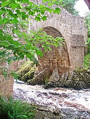
| Tuairisgeul | Feugh Cascades flowing under the Bridge of Feugh, Aberdeenshire, Great Britain |
| Ceann-là | |
| Tùs | From geograph.org.uk; transferred by User:Multichill using geograph_org2commons. |
| Ùghdar | C Michael Hogan |
| Cead (Ag ath-chleachdadh an fhaidhle seo) |
Creative Commons Attribution Share-alike license 2.0 |
| Urram (required by the license) | C Michael Hogan / Feugh Cascades flowing under the Bridge of Feugh / |
| Camera location | | View this and other nearby images on: OpenStreetMap |
|---|
| Object location | | View this and other nearby images on: OpenStreetMap |
|---|
_region:GB-GBN_heading:45.00&language=gd)
Ceadachadh

|
This image was taken from the Geograph project collection. See this photograph's page on the Geograph website for the photographer's contact details. The copyright on this image is owned by C Michael Hogan and is licensed for reuse under the Creative Commons Attribution-ShareAlike 2.0 license.
|
This file is licensed under the Creative Commons Attribution-Share Alike 2.0 Generic license.
Urram: C Michael Hogan
- Faodaidh tu:
- a cho-roinneadh – lethbhreac a dhèanamh dhen obair, a sgaoileadh is a tar-chur
- ath-mheasgachadh – an obair atharrachadh
- Fo bhuaidh nan cumhaichean a leanas:
- urram – Feumaidh tu iomradh a thoirt air an ùghdar no an neach aig a bheil cead air, dìreach mar a thoill iad (ach chan ann air dòigh a chuireas an sùilean dhaoine gu bheil iad ag aontachadh riut no ri d’ obair).
- co-roinneadh co-ionnann – Ma dh’atharraicheas tu no ma leasaicheas tu an obair seo, ’s urrainn an tionndadh ùr fon cheadachas seo no fo cheadachas coltach ris.
Eachdraidh an fhaidhle
Briog air ceann-là/àm gus am faidhle a shealltainn mar a nochd e aig an àm sin.
| Ceann-là/Àm | Dealbhag | Meud | Cleachdaiche | Beachd | |
|---|---|---|---|---|---|
| làithreach | 17:31, 24 dhen Dùbhlachd 2009 | | 483 × 640 (148 KB) | File Upload Bot (Magnus Manske) | == Summary == {{Information |Description=Feugh Cascades flowing under the Bridge of Feugh |Source=From [http://www.geograph.org.uk/photo/534581 geograph.org.uk]; transferd by User:Multichill using [http://toolserver.org/~magnus/geograph_org2commons.ph |
Cleachdadh an fhaidhle
Tha ceangal ris an fhaidhle seo san duilleag a leanas:
Cleachdadh fhaidhlichean uile-choitcheann
Tha na uicidhean eile a leanas a’ cleachdadh an fhaidhle seo
- Cleachdadh air ceb.wikipedia.org
- Cleachdadh air da.wikipedia.org
- Cleachdadh air en.wikipedia.org
- Cleachdadh air www.wikidata.org